First day: Cruising along the Danube by boat.
Our journey started in the early morning from the port of Belgrade beneath the Branko Bridge by our nice cruiser AQUA STAR MAXIM LUX, handling 100 people on board with the speed of 24 km/h. After seeing Belgrade Fortress we continued towards Smederovo Fortress at the bank of Danube River. Before coming to Smederovo, we have to mention Vinča Culture one of prehistoric cultures on the bank of Danube.
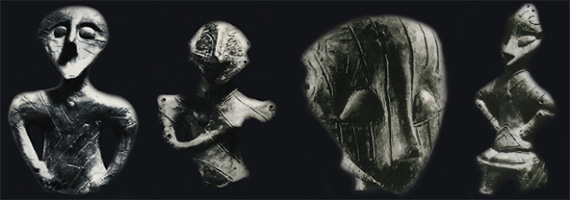
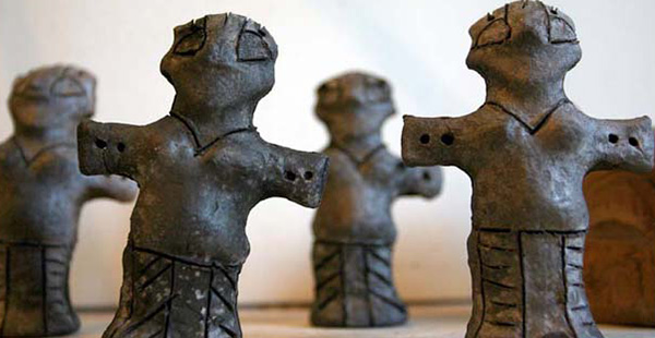
 The Vinča culture, also known as Turdas culture or Turdas-Vinča culture, is a Neolithic archeological culture in Central Europe and Southeastern Europe, dated to the period 5700–4500 BC. Named for its type site, Vinča-Belo Brdo, a large settlement discovered by Serbian archeolog Miloje Vasić in 1908, it represents the material remains of a prehistoric society mainly distinguished by its settlement pattern and ritual behaviour. Vinča culture, having a population boom and producing some of the largest settlements in prehistoric Europe. Various styles of zoomorphic and anthropomorphic figures are hallmarks of the culture, as are the Vinča symbols, which some conjecture to be an early form of proto-writing, the Vinča culture provides the earliest known example of copper metallurgy.
An anthropomorphic figur with incised lines depicting clothing Early Vinča settlement population density was 50-200 people per hectare, in later phases an average of 50-100 people per hectare was common.The Divostin site 4900-4650 B.C. had up to 1028 houses and a maximum population size of 8200 and could perhaps be the largest Vinča settlement.
After being informed about Vinča, our cruising continued towards Smederovo Fortress, which is a mediaeval fortified city in Smederevo, Serbia, which was temporary capital of Serbia in the Middle Ages. It was built between 1427 and 1430 on the order of Despot Đurađ Branković, the ruler of the Serbian Despot. It was further fortified by the Ottoman Empire, that had taken the city, in the end of the century.The fortress withstood several sieges by Ottomans and Serbs, which it survived relatively unscathed. It was not until World War II that it was heavily damaged, by explosions and bombing. Smederevo Fortress, 45 kilometers southeast of Belgrade, covers 11.3 hectares in the center of the modern-day city of Smederevo. It is strategically located on the right bank of the Danube river on the triangular plain formed by the confluence of the Danube and Jezava rivers, only 72 meters above sea level. The fortress is encircled by 1.5 kilometers of crenelated walls over 2 meters thick, and 25 towers which are each approximately 25 meters tall. Two sides were bordered by the Danube and Jezava rivers, though the Jezava has now been redirected away from the wall. The third side had two moats added to the defensive system, one for the inner city and one for the suburb. The area south of the outer walls was left open.The fortress is currently used as a city park and occasionally hosts festivals, concerts, fairs, and other cultural events.
After seeing Smederovo Fortress from Danube, our cruise continued to Ram Fortress, where Danube river makes a lake by entering into the land of Veliko Gradiste… the name of the lake is Silver Lake, which is getting its color when sun shines on it. Veliko Gradiste is a recreational town where you can find nice home pensions and nice hotels for staying during the weekends. The place first finds its reference in Trajan times as a settlement where the cavalry units were stationed. The earliest record of Ram Fortress dates back to 1128, the year, when and where Byzantine army defeated the Hungarians. After victories in this region, Byzantine army have focused their activities on the Panonian Basin. In order to protect the right bank of the Danube Ottoman Sultan Bayezid II (1480-1512) was revised and strengthened the existing fortress for fighting firearms. Ram Fortress represents one of the oldest artillery fort in Serbia.
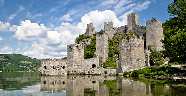
In the continuation of our journey along the Danube River we are coming accross Golubac Fortress, The Golubac Fortress (Turkish: Güvercinlik Kalesi) was a mediaeval fortified town on the south side of the Danube River, 4 km downstream from the modern-day town of Golubac, Serbia. The fortress, which was most likely built during the 14th century, is split into three compounds which were built in stages. It has ten towers, most of which started square, and several of which received many-sided reinforcements with the advent of firearms.
Golubac Fortress has had a tumultuous history. Prior to its construction it was the site of a Roman settlement. During the Middle Ages, it became the object of many battles, especially between Ottoman Empire and Kingdom of Hungary. It changed hands repeatedly, passing between Turks, Bulgarians, Hungarians, Serbs, and Austrians, until 1867, when it was turned over to the Serbian Knez Mihailo Obrenović III. Now, it is a popular tourist attraction in the region and a sightseeing point on Danube boat tours.
It is strategically located on the embankment of the Danube River where it narrows to form the Iron Gate gorge, allowing for the regulation and taxation of traffic across and along the river. In the Middle Ages, this was done with the aid of a strong chain connected to Babakaj, a rock on the far side of the river. Considering the age and location of the Golubac Fortress, it is both large and well-preserved. Its placement at the head of the Iron Gate gorge allowed for easy control of river traffic. It was the last military outpost on that stretch of the Danube river, which caused it to frequently be part of the final line of defense between Hungary and the Ottoman Empire, especially during the periods when Serbia was Ottoman-held. The importance of the fortress is further indicated by the attention it received from Sigismund and Murad II, rather than just fighting between locals and commanders of nearby cities.
 The Golubac Fortress was declared a Monument of Culture of Exceptional Importance in 1979, and it is protected by the Republic of Serbia.
After Fortress of Golubac we reached to Dejerdap National Park, which is located on the right coast of the Danube and stretches from the Golubac Fortress to an ancient fortress Diana with the length of 100km. The surface area of national park is 636 square kilometres which makes it the biggest park in Serbia. As for its natural beauties and culture, it is significant on the European level.
The Djerdap National Park got its name after the most beautiful and the most prominent gorge in the entire flow of Danube. The Djerdap Gorge is one of the largest gorges in Europe. It consist of four gorges and three ravines in the following order.”Golubacka klisura”, “Gospodin Vir Klisura”, “ Donjomilonovacka Kotlina”. Veliki Kazan Klisura”, “Mali Kazan Klisura”, “Orsavska Kotlina”, “Sırpska Klisura”. The most beautiful gorges are “Mali Kazan “ and “Veliki Kazan‘’, where Danube narrows at only 140 metres and reaches the depth of 90 metres, so its bottom is about 30 metres below sea level of the Black Sea.
In the Djerdap National Park there are very rare plant species. On the territory of Djerdap, in the coastal area more than 1000 sorts of plants have been found. It is important to mention the most important of them : walnut, wild lilac, boxwood, nettle, maple, fern etc.
A large number and variety of animal species also represent an important characteristic of this place. Animal species which are typical for this location are deer, boar, rabbit, fox, etc. Rare animal species are bear, lynx, wolf, raccoon and skunk.
Through the valley of Ljupovskalies the second gorge, Gospodjin Vir, which is 15 kilometres long and narrows to 220 metres (722 ft). The cliffs scale to 500 metres and are the most difficult to reach here from land. The broader Donji Milanovac forms the connection with the Great and the Small Kazan gorge, which have a combined length of 19 kilometres (12 miles). The Orsova valley is the last broad section before the river reaches the plains of Wallachia at the last gorge, the Sip gorge.
The Great Kazan (kazan meaning "cauldron" or "reservoir") is the most famous and the most narrow gorge of the whole route: the river here narrows to 150 metres and reaches a depth of up to 53 metres (174 ft). East of this site the Roman emperor Trajan had built the legendary bridge erected by Apollodorus of Damascus over the Danube was a Roman segmental arch bridge, the first bridge to be built over the lower Danube. Though it was only functional for a few decades, for more than 1,000 years it was the longest arch bridge in both total and span length.
The bridge was constructed in 105 AD by instruction of Emperor Trajan by Greek architect Apollodorus of Damascus for the deployment of Roman troops during the conquest of Dacia.
The bridge was situated East of the Iron Gates, near the present-day cities of Drobeta-Turnu Severin in Romania and Kladovo in Serbia. Its construction was ordered by the Emperor Trajan, a supply route for the Roman legions fighting in Dacia.
The structure was 1,135 metres (3,724 ft) long (the Danube is 800 metres (2,600 ft) wide in that area), 15 metres (49 ft) wide, and 19 metres (62 ft) high, measured from the surface of the river. At each end was a Roman castrum, each built around an entrance, so that crossing the bridge was possible only by walking through the ramps.
The bridge's engineer, Apollodorus of Damascus, used wooden arches, each spanning 38 metres (125 ft), set on twenty masonry pillars made of bricks, mortar, and pozzolana cement. It was built unusually quickly (between 103 and 105), employing the construction of a wooden caissonfor each pier.
A Roman memorial plaque ("Tabula Trajana"), 4 metres wide and 1.75 metres high, comemorating the completion of Trajan's military road is located on the Serbian side facing Romania near Ogradina. In 1972, when the Iron Gate I Hydroelectric Power Station was built, the plaque was moved from its original location, and lifted to the present place. It reads:
IMP. CAESAR. DIVI. NERVAE. F
NERVA TRAIANVS. AVG. GERM
PONTIF MAXIMUS TRIB POT IIII
PATER PATRIAE COS III
MONTIBVS EXCISI(s) ANCO(ni)BVS
SVBLAT(i)S VIA(m) F(ecit)
The text was interpreted by Otto Benndorf to mean:
Emperor Caesar’son of the divine Nerva, Nerva Trajan, the Augustus, Germanicus, Pontifex Maximus, invested for the fourth time as Tribune, Father of the Fatherland, Consul for the third time, excavating mountain rocks and using wood beams has made this road.
The Tabula Traiana (the plaque) was declared a Monument of Culture of Exceptional Importance in 1979, and is protected by the Republic of Serbia.
Rock Sculpture Decebalus
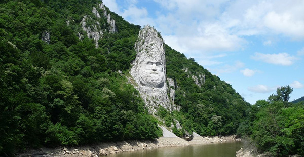
On the Romanian bank, at the Small Kazan, the likeness of Trajan's Dacian opponent Decebalus was carved in rock from 1994 through 2004.
As we move into the Kazan Gorge, where a small valley enters the Danube from the Romanian shore, an enormous head is carved into the rock together with the Latin inscription 'Decebalus Rex - Dragan Fecit'. It turns out to be less ancient than thought, in fact it dates from the 1990s. The carved figure, Decebalus, was a Dacian king who took on the armies of Emperor Trajan and regarded as a great Romanian folk hero. Dragan, more prosaically, is a rich businessman who paid for it to be carved figure. On this slightly ominous note of resurgent nationalism, we pass into the gorge itself. Rock sculpture of Decebalus, king of the Dacians.
The rock sculpture of Decebalus is a 42.9 metres in height and 31.6 metres in width carving in rock of the face of Decebalus, the last king of Dacia, who fought against the Roman emperors Domitian and Trajan to preserve the independence of his country, which corresponded to modern Romania. The sculpture was made between 1994 and 2004, on a rocky outcrop on the river Danube, at the Iron Gate, which form the border between Romania and Serbia. It is located near the city of Orsova in Romania. It is the tallest rock sculpture in Europe.
Significantly older discoveries have been found in the geographically less spectacular gorge of Gospodjin Vir. In the 1960s the archaeological site Lepenski Vir was unearthed, the most important in all of southeastern Europe. The sandstone statues dated to the early neolithic era are particularly splendid. Together with many other findings in the Iron Gates gorges area, they indicate that the region has been inhabited for a very long time.
On our way to Tekije where we are going to take our bus to Kladovo we have seen Monastery Mraconia, which is to be found in the nicest part of the Danube, at the Cazanele Dunari, which was a very important place for directing the ships and giving them instructions. There are considerable differences in the level of the Danube, creating thus dangerous circles.
The church being constructed in 1523 or 1453, the dates differing according to the different opinions of people, was in the valley of Mraconia in a very delighted and beautiful sight, at a very hidden place (Mraconia means a place being hidden). It is known that during the Russian-Austriac-Turkish battle (1787-1792) it was destroyed. In 1823 there was found the ruins along with a slavic proverb being written upon: "Peceat Manastirea Lubostinie Hram Uspenia Presvistaia Bogaraditi Leto 1735."
In 1931 it started the reconstruction of the monastery, however, everything having been reconstructed was stopped in 1967 by the water of the Portile de Fier I. After this the monastery did not get the chance to be reconstructed again. It became the monastery under water, Mraconia. In the year of 1993 the new stone of the new church was put in there, too. From the old monastery however it is still kept the old gate and some other minor parts being exhibited in a museum, Eselnita.
We arrived Tekije and got in our bus to Kladovo to overnight in Aqua Star hotel hotel with 4 stars, which is the best one in the region. Prepared evening meal as open buffet and breakfast in the morning were excellent as well as the comfort in the wide, recently refurbished rooms.
In the morning we have taken our bus on our way back to Belgrade, where on the way we are going to make 3 stops. On the way to Lepenski Vir, which is the oldest residential area in Europe.
Our Guide Miroslav Tasic explained us about the one of the oldest fortresses built by Ottomans, Fetislam Fortress, so that they can control this part of the Balkan area. Apart from that Serbia and Romania has constructed in this part of Danube river one Hydroelectric Power station during the time 1964 -1972.
The construction of the joint Romanian-Yugoslavian mega project commenced in 1964. In 1972 the Iron Gate I Dam was opened, followed by Iron Gate II Dam, in 1984, along with two hydroelectric power stations,two sluices and navigation locks for shipping.
The construction of these dams gave the valley of the Danube below Belgrade the nature of a reservoir and additionally caused a 35 metres rise in the water level of the river near the dam. The old Orsova, the Danube island of Ada Kaleh and at least five other villages, totaling a population of 17,000, had to make their way. People were relocated and the settlements have been lost forever to the Danube.
The dam's construction had a major impact on the local fauna and flora as well—for example, the spawning routes of several species of sturgeon were permanently interrupted.
The flora and fauna, as well as the geomorphological, archeological and cultural historical artifacts of the Iron Gates have been under protection of both nations since the construction of the dam. In Serbia this was done with the Đerdap National Park (since 1974, 636.08 square kilometres (245.59 square miles) and in Romania by the Porțile de Fier National Park (since 2001, 1,156.55 square kilometers (446.55 square miles).
One of the Professional tour guides in our group Mr Tolon explained us the history of Adakaleh, which stayed under the water of Danube after construction of Hydroelectic power station.
The island of Ada Kaleh is probably the most evocative victim of the Đerdap dam's construction. A Turkish exclave, it had a mosque and a thousand twisting alleys, and was known as a free port and smuggler's nest. Many other ethnic groups lived there beside Turks.
 The island was about 3 km (1.9 mi) downstream from Orsova and measured 1.7 by 0.4-0.5 km. It was walled; Austrians built a fort there in 1669 to defend it from the Turks, and that fort would remain a bone of contention for the two empires. In 1699 the island came under Turkish control, from 1716 to 1718 it was Austrian, after a four-month siege in 1738 it was Turkish again, followed by the Austrians reconquering it in 1789, only to have to yield it to the Turks in the following peace treaty.
Thereafter, the island lost its military importance. The 1878 Congress of Berlin forced the Ottoman Empire to retreat far into the south, but the island remained the property of the Turkish sultan, allegedly because it was forgotten to be mentioned in the treaty. The inhabitants enjoyed exemption from taxes and customs and were not conscripted. In 1923, when the Ottoman monarchy had disappeared, the island was given to Romania in the Treaty of Lausanne.
The Ada Kaleh mosque dated from 1903 and was built on the site of an earlier Franciscan monastery. The mosque's carpet, a gift from the Turkish sultan Abdülhamid II, has been located in the Constanța mosque in Romania since 1965.
Most Ada Kaleh inhabitants emigrated to Turkey after the evacuation of the island. A smaller part went to Dobrogea, another Romanian territory with a Turkish minority.
Second day: Returning along the shore of Danube by bus.
On the second day, on our way back to Belgrade by bus ,first stop will be for photoshooting one one of the hills along Danube towards Lepenski Vir is an important Mesolithic archeological site located in Serbia in central Balkan peninsula The latest radiocarbon and AMS data suggests that the chronology of Lepenski Vir is compressed between 9500/7200-6000 BC. There is some disagreement about the early start of the settlement and culture of Lepenskir vir. But the latest data suggest 9500-7200 to be the start. The late Lepenskir Vir (6300-6000 B.C.) architectural development was the development of the Trapezoidal buildings and monumental sculpture.The Lepenskir Vir site consists of one large settlement with around ten satellite villages. Numerous piscine sculptures and peculiar architecture have been found at the site.
Lepenski Vir is located on the banks of the Danube in eastern Serbia, within the Iron Gates gorge, near Donji Milanovac. The first excavations were made on the site in 1965. In 1966 it was listed as a cultural monument of Yugoslavia. It was only in 1967 that its importance was fully understood after the discovery of the first Mesolithic sculptures. The excavations ended in 1971 when the whole site was relocated 29.7metres higher to avoid flooding from a new artificial lake created in the Iron Gates gorge. The main contribution to exploration of this site was through the work of professor Dragoslav Srejović of the University of Belgrade. 136 buildings, settlements and altars were found in the initial excavations in 1965-1970.
Lepenski Vir was declared a Monument of Culture of Exceptional Importance in 1979, and it is protected by the Republic of Serbia.
After visiting Lepenski Vir we went for lunch to Kapetan Mişin Breg etno village on top of one of the hills, becomes a more attractive tourist destination in the region. The captain Miša hill, where tourists will get a cordial and hospitable host of family Stefanovic. This household of much earlier than others realize how important it is to take advantage of natural resources and potential of this area and present them in a proper way to the general public. This time there were 20-30 tourists from Turkey and Germany. In addition they are able to enjoy the natural treasures of this area, specialties Homolje, Stefanovic family is always available to guests and explains the life of the Kapetan Misin Breg, who has given his name to this hill.
So, the story of Captain Misa Anastasijevic, the largest Serbian benefactor, humanist, entrepreneur, the largest rise was its 1866th , when he was one of the richest men in Europe, and that his work emerged over the European scale, and so it really is worth to know, says Zivorad Stefanovic, owner of the gallery.
In the ethno complex you can enjoy:
Healthy food:
After having our nice local lunch in the etno village " Kapetan Misin Breg" and listening to the history of Captain Breg we are again on our way to Belgrade passing through the town Veliko Gradista and its Silver Lake, where Danube enters in to land and makes a lake. Having a coffee break over there, quite nice tourist place, we arrived Belgrade and our hotel.
It was really well done and nice journey. I hope we will have it again for futher occasions.(by Eser Ciddi)